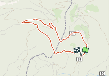
![](/images/other/stat-length.png)
![Randonnée A pied Marling - Marlengo - Martinsweg - Photo](https://media.geolcdn.com/t/1900/400/27c06283-070c-433f-a666-882af6c5e14d.jpeg&format=pjpeg&maxdim=2)
Martinsweg
SityTrail - itinéraires balisés pédestres
Tous les sentiers balisés d’Europe GUIDE+
![Longueur](/images/other/stat-length.png)
![Altitude max](https://static1.geolcdn.com/siteimages/upload/files/1508320355ic_sort_altitude_max_24dp.png)
![Dénivelé positif](https://static1.geolcdn.com/siteimages/upload/files/1508320355ic_sort_den_pos_24dp.png)
![Km-Effort](/images/other/stat-length.png)
![Altitude min](https://static1.geolcdn.com/siteimages/upload/files/1508320355ic_sort_altitude_min_24dp.png)
![Dénivelé négatif](https://static1.geolcdn.com/siteimages/upload/files/1508320355ic_sort_den_neg_24dp.png)
![Boucle](https://static1.geolcdn.com/siteimages/upload/files/16400158638029165_repeat_loop_refresh_sync_direction_icon.png)
![A pied](https://static1.geolcdn.com/sitytour/trail-icons/100.png)
1h36
Difficulté : Facile
![Scannez ce code QR pour ouvrir la randonnée dans l'application SityTrail](https://capi.geolives.com/qq0zvz2zws4bq2lad0pu/sitytour/trails/3123010/qr.png?size=200)
Application GPS de randonnée GRATUITE
À propos
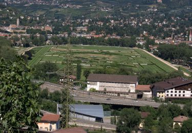
Randonnée A pied de 4,4 km à découvrir à Trentin-Haut-Adige, Haut-Adige, Marling - Marlengo. Cette randonnée est proposée par SityTrail - itinéraires balisés pédestres.
Description
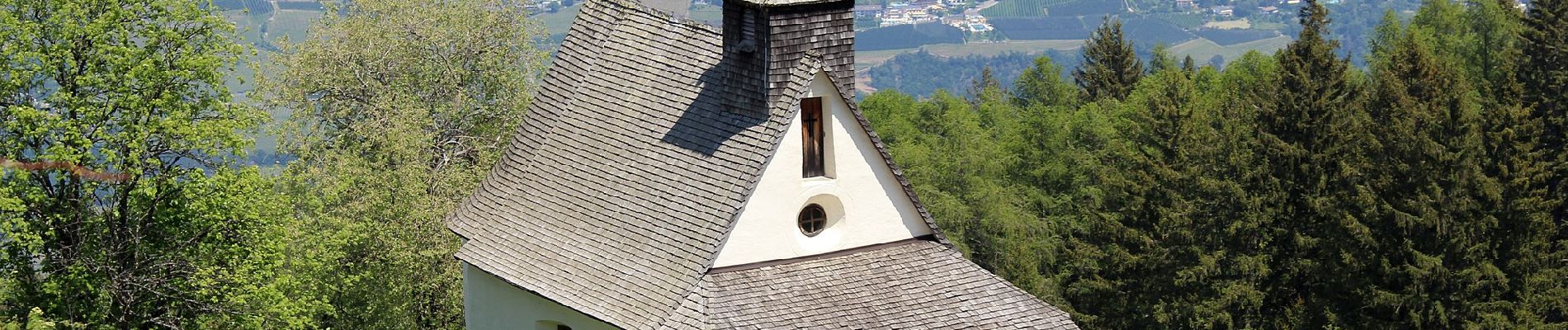
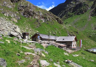
Allgemeine Beschreibung Die Rundwanderung Martinsweg ist ein leicht begehbarer Rundweg, der nach dem Kirchlein St. Martin, nahe der Eggerhöfe benannt ...
Site web: https://www.merano-suedtirol.it/de/marling/aktivurlaub/wandern/themenwege-in-marling/8634493-martinsweg.html
Localisation
Commentaires
Randonnées à proximité
![Randonnée A pied Partschins - Parcines - Kulturwanderweg Peter Mitterhofer - Photo](https://media.geolcdn.com/t/375/260/f108ead9-4af8-4628-bb2d-473e77531df1.jpeg&format=jpg&maxdim=2)
![A pied A pied](https://static1.geolcdn.com/sitytour/trail-icons/100.png)
A pied
![](/images/other/stat-length.png)
![](https://static1.geolcdn.com/siteimages/upload/files/16400158638029165_repeat_loop_refresh_sync_direction_icon.png)
![Randonnée A pied Lana - 34 - Photo](https://media.geolcdn.com/t/375/260/66d95449-dd37-4693-a83b-55672152fab1.jpeg&format=jpg&maxdim=2)
![A pied A pied](https://static1.geolcdn.com/sitytour/trail-icons/100.png)
![Randonnée A pied Tirol - Tirolo - 30 - Photo](https://media.geolcdn.com/t/375/260/f5317dfe-f78f-4d95-a9b0-96e2cc5a325b.jpeg&format=jpg&maxdim=2)
![A pied A pied](https://static1.geolcdn.com/sitytour/trail-icons/100.png)
A pied
![](/images/other/stat-length.png)
![](https://static1.geolcdn.com/siteimages/upload/files/16400158638029165_repeat_loop_refresh_sync_direction_icon.png)
![Randonnée A pied Tirol - Tirolo - Passerweg - Photo](https://media.geolcdn.com/t/375/260/f5317dfe-f78f-4d95-a9b0-96e2cc5a325b.jpeg&format=jpg&maxdim=2)
![A pied A pied](https://static1.geolcdn.com/sitytour/trail-icons/100.png)
A pied
![](/images/other/stat-length.png)
![](https://static1.geolcdn.com/siteimages/upload/files/16400158638029165_repeat_loop_refresh_sync_direction_icon.png)
![Randonnée A pied Marling - Marlengo - 33 - Photo](https://media.geolcdn.com/t/375/260/c0bdaafa-aee9-46a7-a3f2-afed035a75bc.jpeg&format=jpg&maxdim=2)
![A pied A pied](https://static1.geolcdn.com/sitytour/trail-icons/100.png)
A pied
![](/images/other/stat-length.png)
![](https://static1.geolcdn.com/siteimages/upload/files/16400158638029165_repeat_loop_refresh_sync_direction_icon.png)
![Randonnée A pied Marling - Marlengo - Marlinger Waalweg - Photo](https://media.geolcdn.com/t/375/260/6da43a13-fa5e-4e9d-a830-c802515edb81.jpeg&format=jpg&maxdim=2)
![A pied A pied](https://static1.geolcdn.com/sitytour/trail-icons/100.png)
A pied
![](/images/other/stat-length.png)
![](https://static1.geolcdn.com/siteimages/upload/files/16400158638029165_repeat_loop_refresh_sync_direction_icon.png)
![Randonnée A pied Algund - Lagundo - Walderlebnispfad Aschbach - Photo](https://media.geolcdn.com/t/375/260/2522e4bd-1de5-4973-88d0-072aada2e65b.jpeg&format=jpg&maxdim=2)
![A pied A pied](https://static1.geolcdn.com/sitytour/trail-icons/100.png)
A pied
![](/images/other/stat-length.png)
![](https://static1.geolcdn.com/siteimages/upload/files/16400158638029165_repeat_loop_refresh_sync_direction_icon.png)
![Randonnée A pied Algund - Lagundo - IT-7 - Photo](https://media.geolcdn.com/t/375/260/35980617-fb51-45dd-8eb6-596647786abb.jpeg&format=jpg&maxdim=2)
![A pied A pied](https://static1.geolcdn.com/sitytour/trail-icons/100.png)
A pied
![](/images/other/stat-length.png)
![](https://static1.geolcdn.com/siteimages/upload/files/16400158638029165_repeat_loop_refresh_sync_direction_icon.png)
![Randonnée A pied Partschins - Parcines - IT-26 - Photo](https://media.geolcdn.com/t/375/260/d5ae2c00-0b86-4ae2-9ddf-248a64e01869.jpeg&format=jpg&maxdim=2)
![A pied A pied](https://static1.geolcdn.com/sitytour/trail-icons/100.png)
A pied
![](/images/other/stat-length.png)
![](https://static1.geolcdn.com/siteimages/upload/files/16400158638029165_repeat_loop_refresh_sync_direction_icon.png)